 UpToWhere
What can you see from Mount Diablo Peak?
An isolated East Bay peak with extraordinary long-distance visibility.
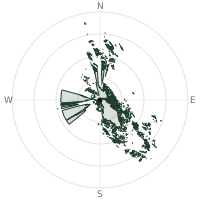
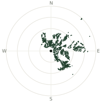
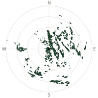
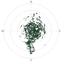
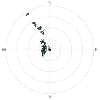
From Mount Diablo Peak, the terrain-limited line of sight reaches up to 198 km. The single farthest piece of visible terrain lies 198 km to the south-southeast (bearing 167°), at 1,784 m elevation. These results account for Earth's curvature and standard atmospheric refraction, computed from 30-meter resolution Copernicus GLO-30 elevation data across 2,089,545 terrain samples.
Open the interactive visibility map →Visibility by direction
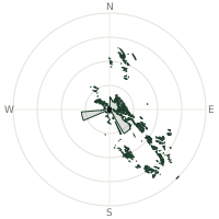
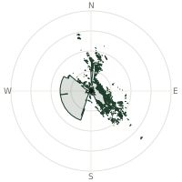
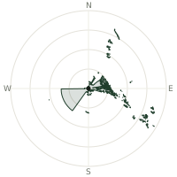
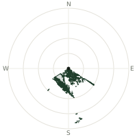
The horizon is most open toward the south, where sightlines run 98.4 km on average; terrain closes the view down fastest to the southwest, at 0.0 km.
| N | 0.0 km | |
| NNE | 0.0 km | |
| NE | 0.0 km | |
| ENE | 0.0 km | |
| E | 0.0 km | |
| ESE | 0.0 km | |
| SE | 51.6 km | |
| SSE | 70.4 km | |
| S | 98.4 km | |
| SSW | 16.5 km | |
| SW | 0.0 km | |
| WSW | 0.0 km | |
| W | 0.0 km | |
| WNW | 0.0 km | |
| NW | 0.0 km | |
| NNW | 0.0 km |
Farthest named landmarks in view
86 named peaks, hills and headlands stand inside this viewshed. These are the farthest ones you could pick out on a clear day:
| Landmark | Visible distance | Direction | Elevation |
|---|---|---|---|
| Junipero Serra Peak | 198 km | SSE · 167° | 1,784 m |
| Black Butte | 182 km | S · 169° | 1,497 m |
| South Ventana Cone | 180 km | S · 172° | 1,517 m |
| Ell Peak | 174 km | SSE · 166° | 1,297 m |
| Paloma Mountain | 170 km | SSE · 167° | 1,207 m |
| Sierra de Salinas | 168 km | SSE · 167° | 1,354 m |
About Mount Diablo Peak
Mount Diablo rises 1,173 meters from the San Francisco Bay Area as an upthrust peak of the Diablo Range. Despite modest elevation, it boasts some of the West's most remarkable visibility, with Lassen Peak visible 181 miles away on clear days. Eight major bridges are visible from the summit.
Did you know?
- On exceptionally clear days, Diablo is said to offer the second-largest area of visible land of any peak on Earth, after Kilimanjaro, thanks to its isolation above the surrounding lowlands.
- Spanish soldiers are said to have named the mountain after Native American warriors who vanished mysteriously into the vegetation during an encounter, an escape the soldiers blamed on 'El Diablo.'
- A beacon on the summit, added in 1928, has been lit every 7 December since as a memorial to Pearl Harbor and an aid to aviators.
- Sierra Nevada mountain range plainly visible from summit on clear winter days.
Frequently asked questions
How far can you see from Mount Diablo Peak?
On a clear day the terrain allows a line of sight of up to 198 km from Mount Diablo Peak. The average visible distance across all 360 directions is 14.9 km. Atmospheric conditions (haze, humidity) usually reduce practical visibility below the terrain-limited maximum.
What is the farthest point visible from Mount Diablo Peak?
The farthest terrain visible from Mount Diablo Peak lies 198 km to the south-southeast, at an elevation of 1,784 m. Earth's curvature and atmospheric refraction are accounted for in this calculation.
How high is Mount Diablo Peak?
The observation point at Mount Diablo Peak sits at 1,161 m above sea level (Copernicus GLO-30 elevation model).
How is this visibility map calculated?
UpToWhere traces lines of sight in 360 directions from the observer using 30 m-resolution Copernicus terrain data, correcting for Earth curvature and standard atmospheric refraction. You can run the same analysis for any point on Earth with the free calculator.
Run your own analysis
Want to know what you can see from your house, a summit you're planning to climb, or a plot of land? UpToWhere computes the same 360° viewshed for any point on Earth in seconds — free.
Try the viewshed calculator